This July, wildfires forced more than 300,000 people from their homes across Spain and France, with the area burned in Spain jumping by roughly 20,000 hectares in a single day at one point last week, according to the country's prime minister. It's not an isolated story. Canada has close to 800 fires burning as of its government's latest update this month, with more than 1.4 million hectares gone already this season. In the US, close to 40,000 fires have burned over 3.6 million acres by mid-July, well ahead of the ten year average for this point in the season, and the Pacific Northwest alone has already crossed a million acres burned across 95 large fires. None of these numbers are outliers anymore. They're becoming the baseline.
Climate researchers have a name for what's driving this: fire seasons that start earlier, run longer, and in some regions never fully stop. The Canadian Climate Institute has pointed to fires that smolder through winter and reignite the following spring, sometimes called zombie fires. Drought, heat, and vegetation stress are compounding each other in a way that makes ignition easier and containment harder almost everywhere at once.
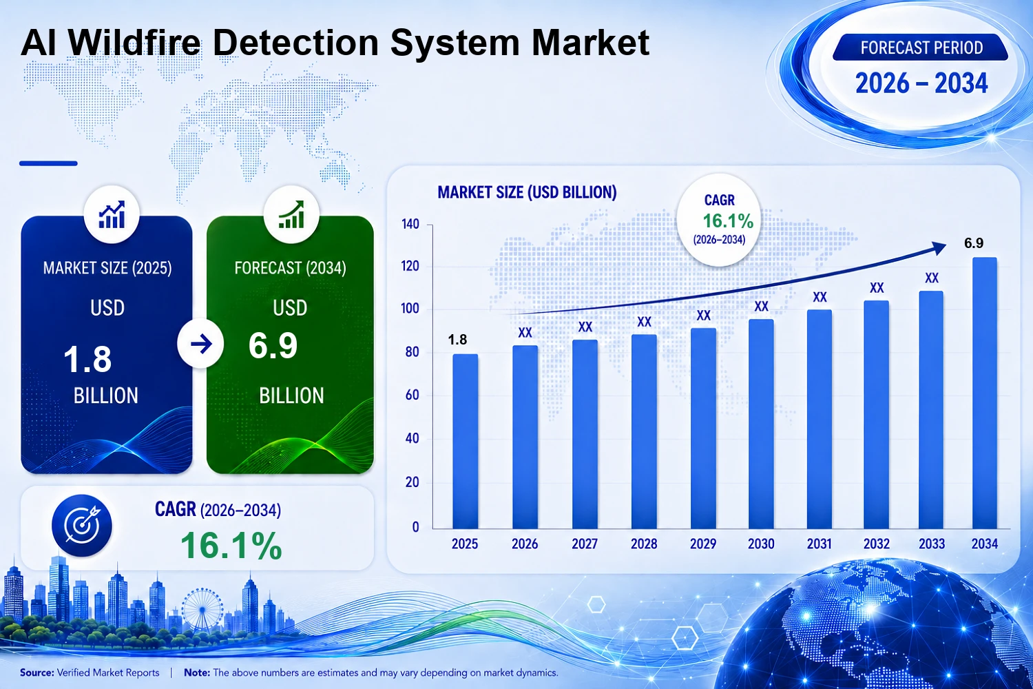
That backdrop is part of why wildfire detection has quietly become one of the more active corners of climate tech. Analysts put the global market for early detection technology at close to seven billion dollars by 2034, growing at better than 16 percent a year. The more interesting story isn't the dollar figure though, it's what companies are actually racing to build, and why speed keeps turning out to be the hardest part to solve.
From Watchtowers to AI-Driven Cameras
Camera based systems have led the way so far. Pano AI's panoramic, AI scanned cameras now watch over more than 50 million acres of fire prone land across the US, Canada, and Australia. Utilities have taken notice. Xcel Energy is expanding its Pano AI camera network across northwestern Wisconsin through the end of this year, and Portland General Electric has credited similar systems with spotting fires faster than human lookouts or 911 calls across four of its highest risk counties. The logic is simple: a camera scanning continuously will almost always beat a system that only checks in every so often.
Satellites and the 20-Minute Revisit Gap
Checking in every so often is exactly the limitation satellite detection has been racing to shrink, and it just took its biggest step yet. On July 7, as smoke from hundreds of fires blanketed Canada and the US, the first three operational satellites in Google's FireSat program launched from Vandenberg Space Force Base. Built by Muon Space for the nonprofit Earth Fire Alliance, with backing from Google.org and a 26 million dollar grant from the Bezos Earth Fund, the satellites carry multispectral sensors that can see through smoke and cloud cover to spot fires as small as five by five meters, well below what most existing satellites can pick up. After a three month testing window, fire agencies in California, Colorado, Australia, and Portugal will start receiving the data this year. The full constellation, more than 50 satellites revisiting every point on the planet within 20 minutes, isn't expected until the early 2030s. Even then, 20 minutes is still 20 minutes. It's a genuine leap for tracking how a fire spreads across a huge, camera-sparse landscape. It's a different kind of tool from something built to catch the first minute of smoke above one specific ridge.
High Liability and the New Utility Risk Playbook
Utilities have their own reasons to care about all of this, beyond public safety. Southern California Edison is now facing close to a thousand lawsuits tied to last year's Eaton Fire in Altadena, which killed 19 people and destroyed more than 9,400 structures. The utility has acknowledged that circumstantial evidence points to one of its idled power lines, and the first bellwether trial is scheduled for January 2027. PG&E's 2019 bankruptcy, tied to wildfire liability from earlier fires, is still the reference point every utility risk officer keeps in the back of their mind, which is probably why PG&E's newest wildfire mitigation plan puts data governance and operational visibility at the center of its strategy rather than treating them as an afterthought. National Grid in the UK is now paying outside firms to remodel where its fire risk actually sits, since the danger doesn't always line up with old assumptions about dense forest or urban proximity. Researchers at Oak Ridge National Laboratory are even testing AI tools with Southern California Edison that watch for the electrical arcing that tends to precede an ignition, trying to catch the fault before there's a spark to see at all.
The Shift Toward Layered, Edge Intelligence
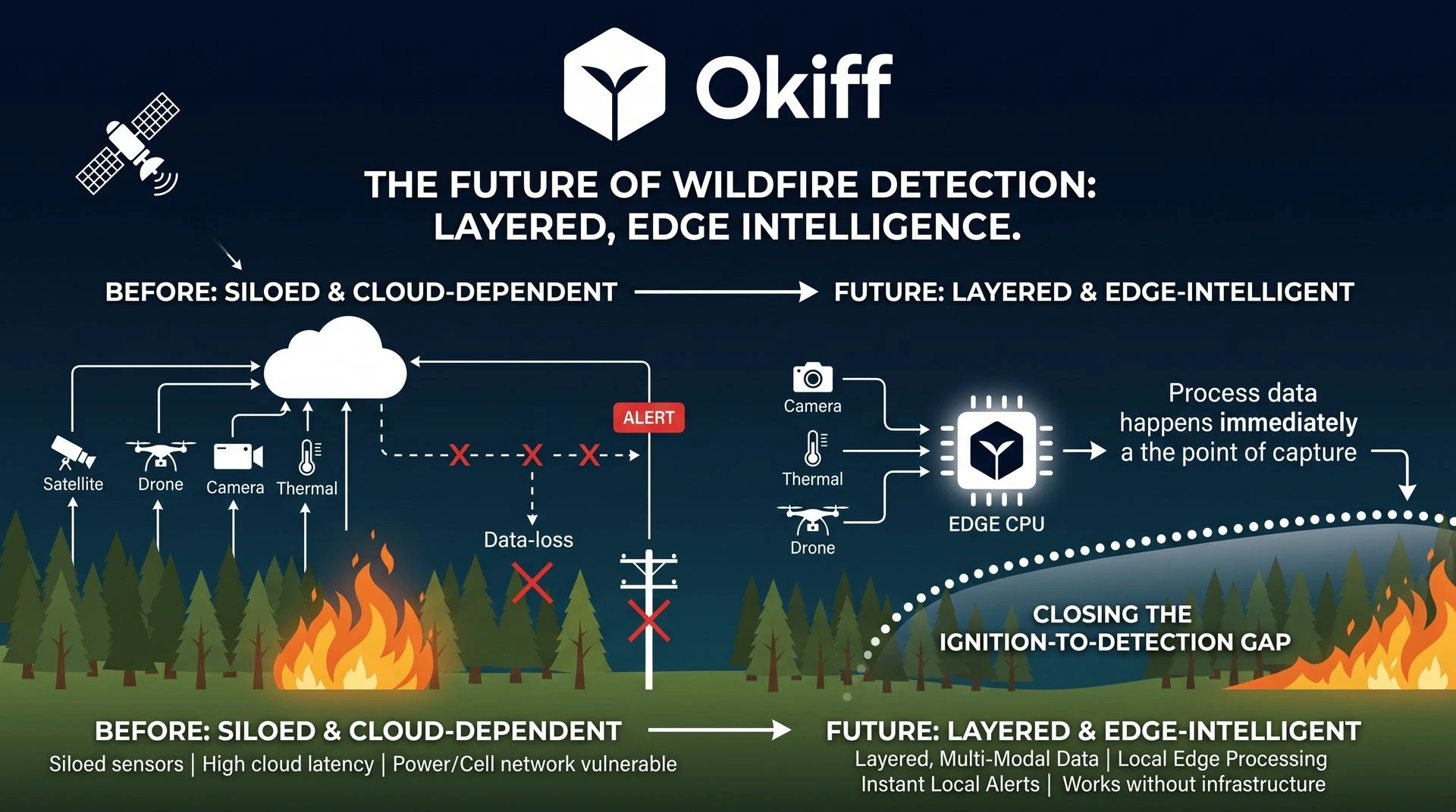
What ties all of this together is a shift in how the industry thinks about detection itself. For years the question was which sensor works best: cameras, satellites, drones, thermal. Increasingly the answer looks like none of them alone. A fire doesn't wait for a satellite's next pass, and a camera can only watch what's in its line of sight. The systems showing the most promise now layer several of these together and process what they see at the point of capture, rather than waiting on a round trip to the cloud. That last part matters more than it sounds like it should, given that a wildfire tends to take out cell towers and power lines before it takes out much else.
None of this makes the fires themselves any less alarming. What it does suggest is that the gap between ignition and detection, the part of a wildfire's timeline that's actually within our control, is finally starting to close. Whether that's fast enough to keep pace with a season that keeps arriving earlier and burning longer is the question the rest of this year will answer. We've gone deeper into how layered, edge based detection works in practice on our wildfire mitigation and response page, for anyone who wants to see the mechanics.